
Scales of Hazards
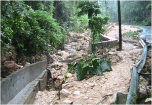
Even in this El Nino year, it’s worthwhile to note that earthquakes don’t have seasons, and aren’t influenced by climatic trends. Also, Jamaica is vulnerable to landslides and floods as well. Sometimes these occur as secondary impacts of hurricanes or earthquakes, or other times they can occur all by themselves (with the appropriate trigger). Take, for instance, Fern Gully. Last April, a massive cloudburst caused significant damage in the Fern Gully and Ocho Rios regions (see photo, courtesy of WRA). Yet this shouldn’t be surprising on many scales and levels. Firstly, Fern Gully is a gully. It’s as simple as that, and until water starts flowing uphill, there are certain inevitabilities that will occur. Secondly, Ocho Rios is on a debris fan. That’s why all the material scoured from the Fern Gully region ended up there and buried Main Street. Thirdly, it’s happened before, on December 25, 1995. It’ll happen again if we don’t stop putting band-aids on after each event.
To be clear, this is not my personal opinion here – this is scientific fact. I’m not passing judgement on people, or indicting developers etc. But people need to know the realities of where they live. Engineering can then come into play – IF it’s properly done, and takes into consideration the natural conditions. Engineering solutions with horse blinders on solves nothing. Done properly, however, engineering can work wonders in mitigating disasters, by channeling run-off away and stabilizing structures. Look at Tokyo, the world’s most populous city, situated within the ring of fire in the Pacific. Look at San Francisco.
Proper land use management and policy controls also serve to help, but again, this has to be driven by information.
But how to filter all the noise out there, to make this information useful and meaningful? Firstly, there is a perception issue, in the way hazards themselves are described, and the way places are described. Saying Fern Gully was affected is fairly straight-forward, but certainly not ALL of Ocho Rios was affected by the April event. And none of Fern Gully or Ocho Rios was affected by a hurricane or earthquake in that event either. Nature doesn’t recognize neat human boundaries (the community of Ocho Rios for that matter), but Fern Gully is a gully, so that’s easy.
Secondly, the way we refer to events and the routine we go through is also counter-intuitive. Hurricane coming? People living in low-lying areas should move to high ground! Am I in a low-lying area? Where is higher ground – upstairs? What am I at risk from in low-lying areas? Floods? Landslides from upslope burying me? What IS low-lying? Valleys or coastal areas? Move to the nearest shelter! Where is this? Is the shelter itself in a low-lying area? Expect winds of 150 mph! Where? I live in a valley and I’m sheltered from high winds – but I should move from this low-lying area, right? And I’m not even getting into the more sinister reasons why people won’t move.
And what would all this mean to an Ocho Rios resident affected by last April’s event? Not a thing.
The Gleaner reserves the right not to publish comments that may be deemed libelous, derogatory or indecent.
To respond to The Gleaner please use the feedback form.
Older Posts
- The shrinking widening world
- Style, no substance; Substance, no style; no Style no Substance
- Response after the Response
- World Cup Reality Check
- Energy Challenges
- Top Jamaican Scientists
- The Annual 12-Month Hazards Season
- A blog about blogs
- Playing to our Strengths
- Deep Sea Nightmare
Other Blogs

Social Bookmarks
Bookmark this:


| M | T | W | T | F | S | S |
|---|---|---|---|---|---|---|
| «-» | ||||||
| 1 | 2 | 3 | 4 | 5 | ||
| 6 | 7 | 8 | 9 | 10 | 11 | 12 |
| 13 | 14 | 15 | 16 | 17 | 18 | 19 |
| 20 | 21 | 22 | 23 | 24 | 25 | 26 |
| 27 | 28 | 29 | 30 | 31 | ||
- Gleaner Company Websites
- Jamaica Gleaner
- The Star
- Go Jamaica
- Go Local
- Sports Jamaica
- Sports Caribe
- Hospitality Jamaica
- Youth Link
- Voice UK
- Gleaner Company Websites
- Business Directory
- Gleaner Classifieds
- Kingston Restaurant Week
- Financial Gleaner
- Discover Jamaica
- Discover Caribe
- Returning Residents
- Go Jamaica hosting
- Contact Info
- RSS Feed
- Contact Us