
Natural hazards and development in Jamaica
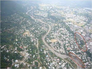
Dangerous settlement patterns along Hope River
As we approach the start of another hurricane season, I’m still concerned about the preparedness level in Jamaica. It seems that there is no end to people wanting to develop and redevelop vulnerable areas, yet I don’t see any checks and balances being done to prevent this in any real sense. Sure we hear a lot of talk, but I don’t see this being translated in to practice.
By the way, earthquakes, floods and landslides, the other 3 hazards we’re vulnerable to, don’t have seasons…
Still, insurers, engineers, disaster managers and the general public seem to dwell on the June-November period, and it’s as good a time as any. But nearly a year on, we haven’t seen any movement on the Hope River valley, which was devastated by TROPICAL STORM Gustav last year. Over a year later, and Fern Gully is just starting to get fixed after the NON-HURRICANE heavy ranfall last April. And we still see housing developments popping up in Jack’s Hill etc.
Check out this 3D virtual tour of Jack’s Hill done by the Mona GeoInformatics Institute and the Unit for Disaster Studies at UWI. We’re coming out with some cool new tools for the natural hazards realm shortly, including our Natural Hazards Atlas, Natural Hazards Simulator and the Natural Hazards Locator System. Check out our booth at the Green Expo this weekend!
Here’s the link to some of our hazards work so far.
Tags: Jamaica, natural hazards
The Gleaner reserves the right not to publish comments that may be deemed libelous, derogatory or indecent.
To respond to The Gleaner please use the feedback form.
Older Posts
- The shrinking widening world
- Style, no substance; Substance, no style; no Style no Substance
- Response after the Response
- World Cup Reality Check
- Energy Challenges
- Top Jamaican Scientists
- The Annual 12-Month Hazards Season
- A blog about blogs
- Playing to our Strengths
- Deep Sea Nightmare
Other Blogs

Social Bookmarks
Bookmark this:


| M | T | W | T | F | S | S |
|---|---|---|---|---|---|---|
| «-» | ||||||
| 1 | 2 | 3 | 4 | 5 | ||
| 6 | 7 | 8 | 9 | 10 | 11 | 12 |
| 13 | 14 | 15 | 16 | 17 | 18 | 19 |
| 20 | 21 | 22 | 23 | 24 | 25 | 26 |
| 27 | 28 | 29 | 30 | 31 | ||
- Gleaner Company Websites
- Jamaica Gleaner
- The Star
- Go Jamaica
- Go Local
- Sports Jamaica
- Sports Caribe
- Hospitality Jamaica
- Youth Link
- Voice UK
- Gleaner Company Websites
- Business Directory
- Gleaner Classifieds
- Kingston Restaurant Week
- Financial Gleaner
- Discover Jamaica
- Discover Caribe
- Returning Residents
- Go Jamaica hosting
- Contact Info
- RSS Feed
- Contact Us